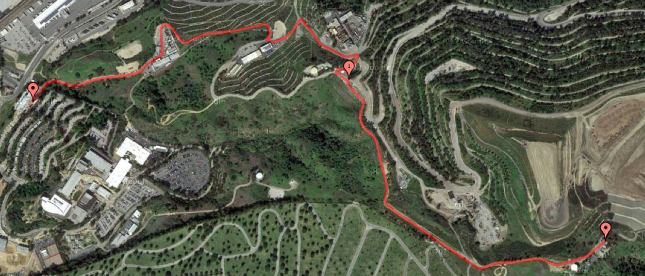
The marker in the top left of the image (click it for the bigger picture) is the bottom of what’s referred to as Nike Hill in Whittier and the marker in the bottom right is the top. In between those two point, it’s 1.81 miles at an average grade of 9%. To put that grade percentage into context, it’s usually at the start of a 7% descent on a highway that signage will be found warning motorists to “Watch Downhill Speed.” In other words, while it ain’t anywhere close to the hellacious steepness of the 32%-33% grades found nearby to me on Echo Park’s Baxter and Fargo streets, Nike Hill’s incline is one worthy of respect, especially if you are tasked with running from the bottom to the top, which I had to do yesterday afternoon at the end of a long day of training.
If you want me to get technical, Nike Hill doesn’t really begin until the top of that distinct outward bend you see in the first segment of the route. From there it’s 1.5 miles at an overall 8.5% grade. But for me as a student at Rio Hondo College in its public safety training program, the runs we do up it start just outside the campus’ Administration of Justice Building, adding about a third of a mile and a couple hundred more feet of elevation gain.
Nike Hill is not so known because of some naming rights agreement entered into with the shoe company. It is called what it is because at that end point is what once was Nike Missile Site LA-14, in operation between 1956-1961, one of hundreds built across the country and 16 active in Los Angeles during the Cold War era.
The Fort MacArthur Museum website states:
Nike missiles were launched from a self-contained launch area. Each site was equipped with two or three launching platforms each with an underground storage magazine, an elevator and four missile erectors. The missiles were stored underground on rails and were brought to the surface by an elevator. Once on the surface, they were pushed on rails to an erector and with the proper electrical and hydraulic connections completed, raised to an angle of about 85 degrees for firing. The Nike missiles employed the “command guidance” system in which the major control equipment was ground-based and not part of the expendable missile. The missiles were guided from a control area located at least 1000 yards from the launch area. It contained the radar equipment for acquiring and tracking the target and missile. Separate radars simultaneously located and tracked both the target and the Nike missile. Data from these radars was fed to the electronic computer which sent “commands” to the missile in flight to guide it to the target.
The installations were designed in the 1950s to defend against the primary strategic attack threat of the time, large formations of long-range bombers. Initially, the missiles onhand were the Nike-Ajax, supersonic anti-aircraft variety.
From “The Missiles of Los Angeles,” via Los Angeles Almanac:
In 1958, the Army began upgrading its Nike missile sites in the Los Angeles area from the Nike-Ajax missile to the more powerful and longer-range Nike-Hercules missile. The new missile could also be armed with a nuclear warhead.
Today the site hosts a set of radio relay towers, and one helluva view on a clear day. And it’s interesting to me that the control area mentioned above was located on the grounds of what eventually became Rio Hondo College, which is celebrating its 50th anniversary this year. On a side note, being about 15 months away from my 50th anniversary, it’s some consolation that I’m not physically older than the institution I’m attending.
But speaking of physically older, I surprise myself by doing all right with this asskicker of a run. It wasn’t at all pretty or noble, but I managed to drag and trudge and flail my 48-year-old butt to the top in 19:57, finishing fourth among my fellow cadets. This with an ongoing aggravated sciatic nerve issue down my left leg and some sort of newly realized mobility limiter in my right ankle.
It’s a stretch, but perhaps my relative success with this run can be traced genetically back to a Scottish ancestry well-acclimated and conditioned to traversing up and down the Scottish highlands. More than likely, I’m simply driven by the knowledge that the sooner I get to the top, the sooner the agony stops.
 Follow