I’m about seven weeks or so into my latest and most favorite evar bike route to and from work that runs roughly 8.5 miles between my home in Silver Lake and my office in Jefferson Park.
It is almost exclusively through quiet (or quieter) residential streets, with the exception of a section on Adams Boulevard which blessedly having recently been dramatically reconfigured between Crenshaw and Fairfax now sports ultra-wide buffered bike lanes.
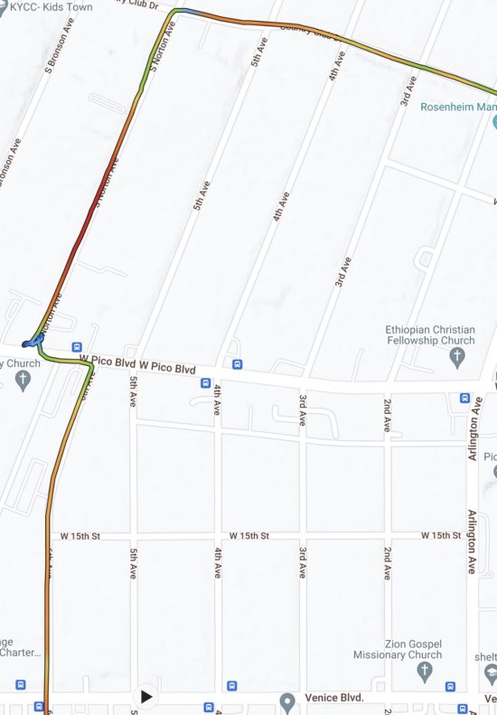
The route is not without its faults — none across Los Angeles is — but its biggest has been the transition to its third act in the mornings, which begins with a run south on 6th Avenue from Pico Boulevard. Almost exclusively I’ve been getting there in the mornings and coming back evenings through the intersection of Norton Avenue at Pico, which is awkward if I’m being kind and a shitshow if I’m being honest. Thanks to a giant landmarked old church building on the south side of Pico Norton north of that boulevard and Norton south of it are not aligned, and especially in the mornings Pico is always gridlocked with traffic heading west. Couple that to traffic signal timers that heavily favor Pico, when and if I finally get the greenlight to proceed (it’s acutally a pretty big if as I’m forced to roll over and punch the pedestrian beg button if there are no other vehicles waiting with me), I have to often thread somewhat precariously through blocking vehicles whose drivers are far more concerned with getting past the jam than waiting for some old white dude on a bike to get across it safely. Once through that I hang a tight right to access 6th Avenue, which while a two-way street, at that point is ridiculously little more than an alley entrance with parking allowed on its east curb. And because of that narrowness I have to be very mindful of any oncoming vehicles, most of the drivers of which are far more preoccupied with getting onto Pico than with sharing the road.
Here’s a route map that shows what I’m talking about. That blue squiggle (blue means slooooooow travel speed) is a GPS representation of me arriving at Pico on Norton, having to roll onto the sidewalk to press the beg button and then return to await an eternity for a green:

Norton Avenue from Pico north to Country Club Drive is in and of itself an aggravation, relatively heavily trafficked and often pocked with double-parked vehicles that need to be navigated around.
But habits tend to cement pretty speedily and that’s been the way I’ve come and gone — until yesterday morning. For whatever reason as I was westbound on Country Club Drive approaching 4th Avenue, I thought “what the hell” and hung a left onto it. To my satisfaction I found it substantially less crowded as well as less impacted by double parkers (who I hold in a disdain second only to those who park in bike lanes).
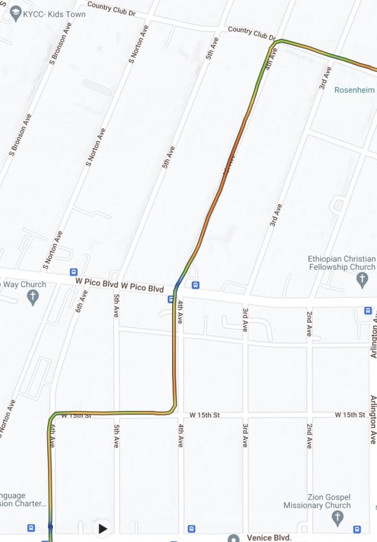
To add joy to my satisfaction, once I crossed Pico (by the way: much quicker and smoother than when crossing at Norton), a very nice buffered bike lane begins that I rode only one block to 15th Street, where I hung a right, traveled two blocks west and then hung a left onto 6th Avenue headed south. Grinning all the way.
Here’s a route map of that (note the lack of blue squiggles:

Is this a little thing? In the grand scheme, of course. But from my perspective looking over a set of handlebars as I thread a bike through a big city, I can’t overestimate the importance and value of such a discovery.
 Follow